By Bapon Fakhruddin, Chair, CODATA TG FAIR Data for DRR, and Emma Singh, Tonkin + Taylor International, New Zealand
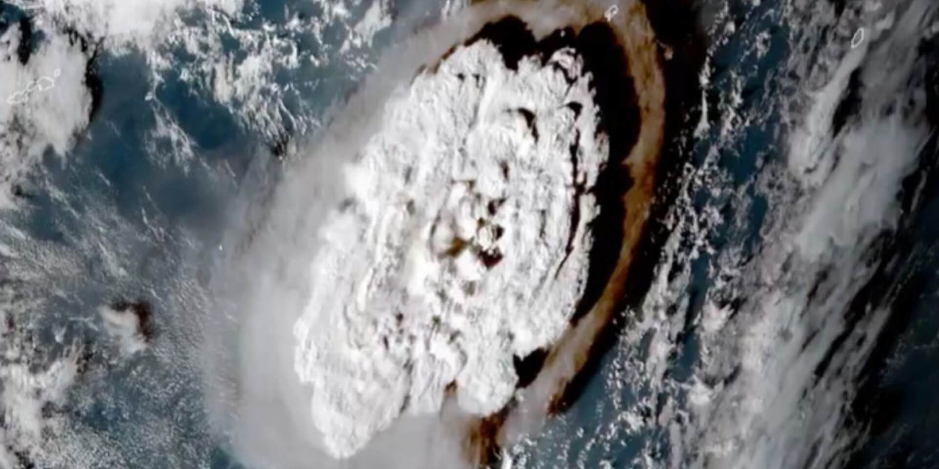
While research communities are trying to better understand complex, compounding and cascading disasters, 2022 has just provided a ‘textbook’ example in Tonga. Tropical Cyclone Cody, the COVID-19 pandemic threat, and the eruption of the Hunga Tonga-Hunga Ha’apai volcano – followed by a tsunami and more than 70 earthquakes (magnitudes 4.4-5.0) between 14 January and 04 February 2022 – devastated the emergency management system in Tonga. The global science community is learning from this event as they grapple with the fact that a single eruption produced a Pacific-wide tsunami of 1.98-2.9 metres, which smashed boats in New Zealand and caused an oil spill and two drownings in Peru, and ice breaking at the mouth of the river in Paramushir Island, Russia. The shock wave from the eruption, a sonic boom with ripple waves that travelled three times around the world, increased the tsunami waves.
The Tonga Geological Services (TGS) commenced reporting on the Hunga Tonga-Hunga Ha’apai submarine volcanic activity on 20 December 2021, with the aviation code immediately heightened to red. On 14 January 2022, TGS reissued an alert following volcanic activity and as the communities in Tongatapu and ‘Eua noticed the smell of sulphur. Eruption of the Hunga Tonga-Hunga Ha’apai volcano started at 17:07 on 15 January 2022, with an ash eruption at 17:14. Tsunami waves from the Hunga Tonga-Hunga Ha’apai arrived at Nukualofa prior to the arrival at any deep ocean (DART) observation sites. The tsunami arrived at 17:32 local time, at 1.98m above sea level. A peak height of approximately 2.9m above sea level was reached at 17:50. Wave run-up was between 15m and 20m above sea level in some areas, with inundation reaching 500m inland at Nomuka, Ha’apai and 600m inland at Mango, Ha’apai. The Tongan Meteorological Service (TMS) reported that the tsunami completely damaged all resorts in ‘Eua[1] and nine major resorts in the Tongatapu islands and Nuku’alofa, and estimated that around 160 homes were seriously damaged or destroyed. According to the National Emergency Management Office, four people died (one foreign national in Tongatapu and three local residents from Ha’apai). The timelines for warning and response are presented in Figure 1.

To compound the event, the undersea fibre-optic cable that connects Tonga to the rest of the world ruptured. Tonga has been connected to this telecommunication network for the last decade and has become heavily reliant on this system, which is often more stable than other technologies such as satellite and fixed infrastructure. Tonga is only connected via a single cable connecting the capital Nuku’alofa to Fiji, with other inter-island cables. This cable snapped on 15 January 2022, due to one or more processes (the tsunami, submarine landslide or other underwater currents) related to the Hunga Tonga-Hunga Ha’apai volcanic eruption. This made it difficult for emergency services and Tonga government officials to communicate and for local communities to determine aid and recovery needs.
The Tsunami (Volcanic Trigger) Hazard Information Profile

Hazard Type: GEOHAZARDS
Hazard Cluster: Volcanogenic (Volcanoes and Geothermal)
Specific Hazard: Tsunami (Volcanic Trigger)
Definition:
Volcano tsunamis (pronounced soo-ná-mees), are a series of waves created when water surrounding a volcano is displaced following an eruption, a landslide, or failure of a volcanic edifice into surrounding water. If the generating mechanism is large enough, the waves can be significant on local, regional or even transoceanic scales (Day, 2015).
See the full list of Hazard Information Profiles here.
The country has a good early warning system with efficient leaders and scientists in both TMS and TGS. The Tonga Ministry of Meteorology, Energy, Information, Disaster Management, Environment, Climate Change and Communications has a significant mandate in disaster risk reduction, integrating several portfolios. Standard operating procedures for the National Emergency Coordination Centre, a national tsunami plan, and tropical cyclone procedures are in place. They provide a guide on the operational links between lead agencies for various hazards within the National Emergency Management Office, the National Emergency Operation Committee, and the National Environment Coordinating Committee. Improving multi-hazard early warning systems is a priority issue under the Tonga Strategic Development Framework 2015-2025 (TSDF II) and National Emergency Management Plan as part of the risk reduction and emergency management process, and well applied for this complex event.
The Pacific Resilience Program (PREP) of World Bank strengthened disaster early warning and preparedness, and mainstreamed disaster risk and climate change in development planning and financing in Tonga. It provided comprehensive and integrated assistance to the Government of Tonga with institutional and regulatory strengthening, capacity building and implementation support, and modernisation of the observation infrastructure, data management systems, forecasting and warning systems. It supported the enhancement of the multi-hazard early warning system service delivery system.
Tsunamis from volcanoes are not adequately forecasted with traditional earthquake magnitude-based approaches. The tsunami resulting from the Tongan eruption was larger and arrived much earlier at distant locations than expected for the earthquake-generated tsunami. Forecasting models and warning systems designed to assess earthquake-triggered tsunami waves did not account for the shockwave from the eruption boosting the waves. This event may enable scientists to understand the science behind how a shockwave pushed large waves across the Pacific to the shores of Japan and Peru, thousands of kilometres away, and to integrate those findings into tsunami hazard modelling. The recent assessment of probabilistic tsunami hazard and risk assessment of Fiji, and other probabilistic hazards such as cyclones, could provide more in-depth understanding of systematic risk.
It is necessary to enhance the ability to measure the tsunami generation process due to eruption and deliver scenarios based pre-impact forecasting at local and regional scale. Pre-impact-based scenario forecasting allows practitioners to interpret the hazard warning and requires partnerships between services provider at national level and in sectors within disaster risk reduction and management. This would result in early actions such as the evacuation of vulnerable communities, individuals and their livestock; pre-deployment of flood barriers, and road and bridge closures. Standard operating procedures need to be reviewed and need to include volcano-generated tsunami warning. Staff training on volcanology needs to be enhanced.
The failure of essential services from critical infrastructure (transportation systems, communication networks, and power and water utilities) during natural hazard events can impact populations by exacerbating the hazard and hindering citizens’ ability to respond to or recover from the event. Understanding the potential flow-on effects from critical infrastructure failure during disasters is vital for disaster mitigation, response and recovery. Not only is it important to make critical infrastructure more resilient to disruption from future shocks, there is also a need to increase resilience by preparing communities to better cope with service outages.
The Tonga 2022 volcanic eruption highlights how fragile the global undersea cable network is, and how quickly it can go offline. This was not the first-time natural phenomena cut off critical submarine cables, and it will not be the last. Governments and telecommunication companies need to find ways to diversify the way we communicate, such as by using more satellite-based systems and other technologies2. In addition to building resilience via rugged two-way satellite communicators, communications and SOS facilities shall be visible in a single dashboard for the country, as a redundancy. Further resilience units with Rugged BGAN Satellite units for specific facilities and centres could ensure a robustness of communication system. These facilities could be transitioned to provide public Wi-Fi for tourists and other network requirements of the area concerned, so the emergency solution rolls into being used for day-to day operations that can benefit the community over the long term.
Tonga has limited ability to provide rapid alert notifications in an emergency, relying on communication systems such as the internet, radio, HF/VHF, email and phone calls. There are no systematic processes or guidelines for rapid alerts and dissemination of information to end users during a hazard event. Early warning could assist communities to better prepare and respond to disasters and minimise losses.
Aside from the actions outlined in the Tonga National Emergency Management Plan, there are no formal and binding agreements between communication providers and the National Emergency Management Office and TMS, which are designated to provide emergency warning information. This is a significant gap in the system and can create confusion between roles and responsibilities for disseminating emergency information. The Tongan Department of Communications is working with the communications providers to eliminate costs for end users during an emergency and to increase access to emergency information. However, this comes at a large cost to the company. A formal emergency communications policy from the government could alleviate this.
A Unified Messaging System (UMS) is the most successful innovation in the domain of emergency alerting. It leverages multiple channels of communication originating from a single point. The system has capacity to handle all applications requiring the broadcast of messages using standard protocols (that is, Common Alerting Protocol (CAP)) and infrastructures (for example, internet, land phone ) available in any country. Siren control devices and others could be customised to UMS for Tongan context. This could be available to the National Emergency Management Office and TMS as a software package designed to activate early warnings for all hazards. The CAP messaging is central to the UMS. It allows systems to interlink with the messaging broker to write, publish, subscribe, and disseminate warnings though all media. More than 30 countries have adopted CAP as the warning standard, and the list continues to grow.
Risk communication is an essential component in reducing disaster risk, especially for medium-range hazard warning systems. Effective communication through hazard forecasting is critical for communities to understand risks and take appropriate actions. As we face a complex environment in which risk is more systemic, national and local governments need to have the ability to successfully communicate hazard risk and actions through a coordinated all-of-society approach.
Strengthening public education and awareness of disaster risks and reduction efforts is essential. This includes increasing uptake of disaster risk information and knowledge through campaigns, social media and community mobilisation, considering the needs of specific audiences. Impact-based early warning systems and anticipatory action-related activities will further enhance the community capacity. An awareness programme on natural warning signs (for example, the smell of sulphur) is required.
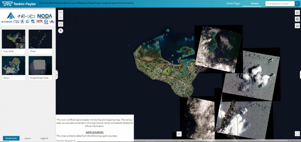
CODATA TG FAIR Data for disaster risk reduction and ChinaGEO supported volunteered disaster emergency response mechanism (VoRDM) under the umbrella of GEO, CODATA and WDS. The rapid damage mapping for Tonga put together all high-resolution satellite and damage information for disaster response to assist the Tongan Government to accurately map the devastation and smooth the way for more efficient humanitarian efforts and recovery (Figure 2).
“Thank you for your generous work, and for thinking of the people in Tonga. NEMO is always grateful for the help that is offered by CODATA and Tonkin and Taylor at this time.”
Operation Manager, EOC-NEMO
VoRDM is designed as a global disaster emergency response mechanism especially for developing countries and regions. During the past five years, RDM has worked on 26 disaster events in more than 20 countries from Asia, Africa, Southern America, Central America, Oceania and Europe. The GEO data principles (DSPs and DMPs) and open science principles are applied to ensure the broad participation from all contributions, the quick reaction of collaboration mechanisms, and smooth flow of emergency information that could be used for pre and post event assessment. The Prime Minister of Tonga, Hon. Siaosi Sovaleni, appreciated CODATA initiatives.
The devastating Hunga Tonga-Hunga Ha’apai eruption and tsunami in Tonga provides many lessons for the future. Certainly, it has highlighted that resilience to natural hazards requires integrated risk management – from hazard identification and risk register, hazard warnings and risk communication – to prepare for hazard events and respond when an event occurs. With the advances in science and multi-model ensembles, warning skills have increased and have the potential to reduce disaster risk. Risk communication is also crucial for minimising losses and damage. Risk communication is not always about convincing people to act in a certain way. Care must be taken to avoid placing undue blame or burden on vulnerable groups in relation to taking action, especially when they have limited power, when it is unclear what actions should be taken, and when structural factors are putting them in harm’s way. It is important to hold open and public conversations about uncertainty, complicated decisions, trade-offs, and responsibilities which are often overlooked as a part of risk communication.

Bapon Fakhruddin
Dr Fakhruddin is an expert climate change risk assessor with 20 years’ global experience in disaster risk and climate resilience projects. His expertise brings major advantages in climate change adaptation and mitigation strategy development, as well as coastal hazard risk assessment, early warning and emergency response and coastal community resilience. Bapon has designed climate change and disaster response projects more than 30 countries in the Asia–Pacific region. He is Chair CODATA task group FAIR Data for Disaster Risk Research.

Emma Singh
Emma is a Senior Natural Hazard and Climate Risk consultant at Tonkin + Taylor. She has 10 years’ international experience in delivering natural catastrophe and climate consulting services, including multi-hazard and climate risk assessments, catastrophe modelling, and quantification and optimisation of insurable risk. She holds a MSc in earth sciences and a PhD in environmental sciences. Emma has researched a wide range of natural hazards and their consequences but has particular passion for volcanic risk, critical infrastructure disruption, climate change risk and risk communication.
[1] Situation Report no 11 (25 January 2022)
Image by Stuart Rankin on Flickr.
 Read more about WorldFAIR: Continuing to transform data to tackle complex challenges in a follow-up project
 Read more about Enhancing disaster preparedness: User feedback drives improvements to UNDRR-ISC Hazard Information Profiles
 Read more about International Science Council appoints new members to IRDR Scientific Committee